Places
The Hardangerfjord: Norway's Orchard Fjord on the Way to Trolltunga
Every road to Trolltunga ends on the Hardangerfjord. Odda, the town below the hike, sits at the very end of its longest inner arm, the Sørfjorden, and whichever way you come from Bergen you drive along, across or under a part of it. Store norske leksikon gives the fjord as 180 km long, measured from Bømlahuk on the coast to Odda, which makes it the second-longest fjord in Norway. Visit Hardangerfjord notes it is the one Norwegians call the queen.
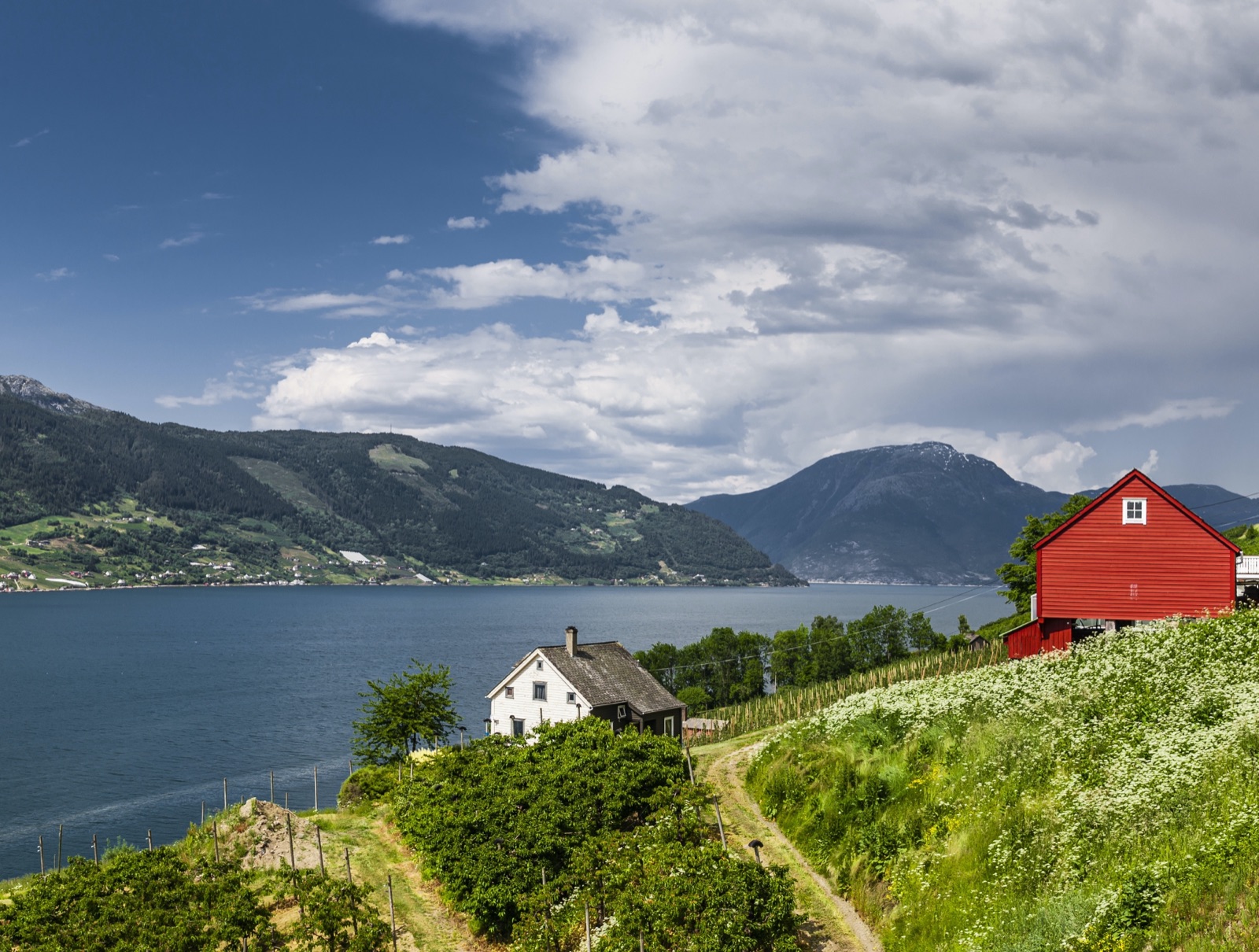
For a visitor it is three things at once: a deep, branching fjord with glaciers and waterfalls above it; the country’s best-known orchard district, with blossom in late spring and cider in the farm shops; and the setting of a series of small villages that you pass on the way to the hike. This article covers the fjord itself, its arms, the orchards and cider, the Hardanger Bridge, the villages and Vøringsfossen, the fjord cruises, and the drive from Bergen. Our article on where to stay near Trolltunga covers Lofthus as a base, and the one on the Troll Tongue tells the hydropower story of the lake below Trolltunga.
The short answer
- Length: 180 km including Bømlafjorden and the Sørfjorden, in Store norske leksikon; Visit Hardangerfjord and the cruise operator Norled give 179 km.
- Depth: 855 metres at its deepest, off Herand in outer Samlafjorden.
- The arm to Trolltunga: the Sørfjorden, which runs 38 km south to Odda.
- Orchards: fruit has been grown here since around 1300; blossom lasts from about mid-May to mid-June.
- Cider: “Sider frå Hardanger” has had a protected name since 17 April 2009.
- Bridge: the Hardanger Bridge, opened in 2013, with a main span of 1,310 metres.
- Cruise: a daily boat runs between Norheimsund and Eidfjord from May to September.
- From Bergen: about 3 hours by road to Odda.
How long and how deep
Store norske leksikon describes the Hardangerfjord as the second-longest fjord both in Vestland county and in Norway. Including its outer part, Bømlafjorden, and its longest inner arm, the Sørfjorden, it is 180 km long, from Bømlahuk to Odda. The cruise listing on Visit Hardangerfjord gives 179 km. The difference is a matter of where you start and end the measurement, not of the fjord.
Up to the junction at Utnefjorden it is two to ten kilometres wide; the arms are mostly much narrower. The greatest depth, 855 metres, is off Herand in outer Samlafjorden, a reminder that the fjord is a deep trench cut by ice and then flooded by the sea, not a gentle inlet.
The name is old. Store norske leksikon explains that Hardanger was originally the name of the fjord. It combines the Old Norse people name hǫrðar, or the adjective harðr, “hard”, with angr, meaning “narrow fjord”.
The arms of the fjord
From the coast inward, the fjord changes name several times. Bømlafjorden runs about 25 km from Bømlahuk to the southern tip of the island of Stord. From there the fjord runs about 100 km north-east to the mouth of the Sørfjorden, under a string of local names: Halsnøyfjorden, Husnesfjorden, Kvinnheradsfjorden past Rosendal, Sildafjorden with the side arm Maurangerfjorden (also written Maurangsfjorden), Hissfjorden past Jondal, outer and inner Samlafjorden, and finally Utnefjorden past the village of Utne.
At the head of Utnefjorden it splits:
- Granvinsfjorden runs north-east towards Granvin.
- The Sørfjorden runs 38 km south to Odda.
- Eidfjorden, with its innermost part Simadalsfjorden, runs 28 km north-east and then east to Simadal.
- Osafjorden branches north-east from Eidfjorden to Osa, and Ulvikafjorden leads off it to the village of Ulvik.
These are Store norske leksikon’s lengths for single stretches, two of them given only as round figures. Added up, they come to less than its 180 km for the whole fjord, so read them as a rough guide to each part, not as a breakdown of the total.
One more arm deserves a mention: Fyksesund, a very narrow inlet that cuts northwards for ten kilometres from outer Samlafjorden. Visit Hardangerfjord describes it as roadless, with cascades falling directly into the fjord from both sides, and boat trips run into it.
The Sørfjord: the arm that leads to Trolltunga
For Trolltunga, the Sørfjorden is the arm that matters. It is long and narrow, with Folgefonna on the high ground to the west and Hardangervidda to the east. National road 13, which Store norske leksikon calls the main north–south road of Hardanger, runs from Voss over Granvin and along the east side of the Sørfjorden to Odda and on to Røldal.
On that east shore you pass the orchards of Lofthus, then the industrial village of Tyssedal, where the road to the Trolltunga trailhead begins, and finally Odda at the head of the fjord. Odda had 4,750 inhabitants in 2025 and is the largest settlement in Hardanger. Our guide to Odda covers the town, and our guide to getting to Trolltunga covers the car parks and shuttle buses from there.
The contrast between the two ends of the Sørfjorden is part of its interest. The Lofthus end is fruit country. The southern end is shaped by hydropower and smelting, which our article on the Troll Tongue explains. Across the water, Folgefonna’s ice is in view from places such as Lofthus, and our article on Folgefonna and Buarbreen covers the glacier.
Orchard country
Store norske leksikon describes the fjord sides as sheltered slopes with lush vegetation and farmland, including large orchards, and notes that fruit growing in Hardanger is significant even on a national scale. Visit Hardangerfjord places Lofthus in Norway’s largest fruit-growing area, and the cruise listing describes orchards holding hundreds of thousands of fruit trees stretching down to the water.
The tradition is medieval. The Norwegian cider regulation, published on Lovdata, records that English monks are credited with bringing fruit-growing knowledge to Hardanger around 1300. Store norske leksikon credits the monks of Lysekloster, Norway’s oldest Cistercian monastery, founded in 1146 by monks from Fountains Abbey near York. The Norwegian Scenic Routes put it simply: in Hardanger, fruit farming has taken place since the 14th century.
The industry is still active. Lofthus has a state research centre for fruit growing, and Store norske leksikon calls Ulvik a large fruit municipality, where apple growing and processing is an important industry. Apples are the best known, but Visit Hardangerfjord mentions pears and plums on the same slopes, and Fjord Norway notes the roadside stalls selling fruit and juice in summer and autumn.
Blossom time
The blossom is the reason many people time a trip for late spring. Visit Hardangerfjord gives the season as about mid-May to mid-June. Store norske leksikon’s description of Folgefonna National Park captures the scene: the contrast between the snowfields on the glacier and the blue-green Sørfjorden below, surrounded by green slopes and blossoming white apple orchards.
That season overlaps with the waterfalls at their fullest. Visit Hardangerfjord says late April through early July is when the waterfalls are most powerful, fed by snowmelt, so May and early June give you both. It is also before the main Trolltunga season: Trolltunga AS’s summer season for hiking on your own opens on 1 June, and the trail is often under snow until May–June, as our article on Trolltunga weather explains. If you want blossom and Trolltunga on one trip, aim for June and check the trail conditions before you go. Blossom dates move with the weather each spring.
Cider from Hardanger
Hardanger’s apples end up in a glass as often as in a bag. Fjord Norway calls Hardanger the major fruit and apple-growing region in western Norway and home to the country’s largest cider production, and notes that “Cider from Hardanger” was the first alcoholic product in Norway to get a protected geographical indication.
The rules are set out in a regulation laid down by the Norwegian Food Safety Authority on 17 April 2009. Sider frå Hardanger must be cider made in Hardanger from apples grown in Hardanger, and the growing, pressing, fermenting and storing must all take place in the municipalities of Eidfjord, Granvin, Jondal, Kvam, Odda, Ulvik and Ullensvang. Apple concentrate may not be used.
The same regulation gives a short history. From about 1890 into the 1920s, cider production had its heyday in Hardanger, with factories at places such as Alsåker, Aga, Lutro and Stana. Most closed when strict new alcohol laws came in in 1921, and until production and sales were liberalised in the 1990s, cider-making survived mainly as cellar production for home use.
Today, along the fjord, numerous fruit farms offer tastings and guided tours during the season. In Ulvik, the fruit and cider route links three farms, Ulvik Frukt & Cideri, Syse Gard and Hardanger Saft- og Siderfabrikk, with guided tours and farm shops. If you are driving, plan the tasting for the day you are not behind the wheel.
The Hardanger Bridge
The single biggest change to travel in the region is the Hardanger Bridge, Hardangerbrua. Store norske leksikon describes it as a two-lane road bridge on national road 13 in Eidfjord and Ulvik. It crosses the fjord between Vallavik and Bu, where it meets road 7, the main road east over Hardangervidda.
Some figures:
- Built: approved by Parliament in 2006, started in 2009, opened on 17 August 2013.
- Size: 1,380 metres long in total, with a main span of 1,310 metres and a clearance of 55 metres for shipping.
- Towers: 201.5 metres high at Bu and 193.5 metres at Vallavik.
- Ranking: Norway’s second-longest suspension bridge after Hålogalandsbrua, though its longest span is longer.
The approaches run through tunnels on both sides, and include 900 metres of footpath and cycle path. Store norske leksikon notes that the bridge has been important for inner Hardanger and the Bergen area, even if traffic has so far been lower than forecast.
Villages along the way
You will pass several of these on the way to Odda. Each is worth a stop of an hour or a night.
Norheimsund
The administrative centre of Kvam, on the north-west shore of the fjord, with 2,366 inhabitants in 2025. A few kilometres west on road 49 is Steinsdalsfossen, which Visit Hardangerfjord describes as a 50-metre waterfall with a paved path that takes you behind it without getting wet. Norheimsund is also where the fjord cruise starts.
Utne
A small village on Utnefjorden, near the mouth of the Sørfjorden, and home of the Hardanger Folk Museum, with folk costumes, fiddles and farm buildings. Fjord Norway notes that the historic Utne Hotel opened in 1722 and has been run as a hotel ever since.
Kinsarvik
Across the water from Utne, linked to it by car ferry. Visit Hardangerfjord notes one of Norway’s oldest stone churches, dating from the 1100s, and the start of the hike up Husedalen, a valley with four waterfalls, 5 km one way with 700 metres of climbing.
Lofthus
The orchard village on the Sørfjorden, with 601 inhabitants in 2025. Ullensvang church here is a medieval stone church built in English Gothic style, and Edvard Grieg’s composer’s hut stands in the garden of Hotel Ullensvang. Fjord Tours puts the Trolltunga starting point about 30 minutes by car from Lofthus. Our where-to-stay article covers Hotel Ullensvang as a base.
Ulvik
At the head of Ulvikafjorden, a fruit village with 542 inhabitants in 2025 and the fruit and cider route described above.
Eidfjord
At the head of the fjord, where the road climbs up to Hardangervidda. Hardangervidda National Park covers about 38 per cent of the municipality, and 90 per cent of its land lies over 900 metres above sea level. It has the Norwegian Nature Centre Hardanger and, above the village, Vøringsfossen.
Vøringsfossen
If you see one big waterfall on the Hardangerfjord, this is it. Store norske leksikon describes Vøringsfossen as a 182-metre waterfall on the river Bjoreio (Bjoreia in that article) in Måbødalen, in Eidfjord, beside road 7 over Hardangervidda. The Norwegian Scenic Routes describe vast quantities of water plunging 182 metres down from the plateau into the valley.
The water is partly regulated. Water from Bjoreio is transferred to the Sy-Sima power station, but in the tourist season, 1 June to 15 September, a relatively large flow of 12 cubic metres per second is released into the falls. Visit Hardangerfjord adds that the regulation can affect the flow at certain times.
The site has been rebuilt by the Norwegian Scenic Routes. It has more than a kilometre of secured paths, several viewpoints, and a step bridge over the river Bjoreio that links the upper area at Fossli with the lower plateau at Fossatromma. A new car park with toilets and EV charging opened at Fossatromma in September 2024, open approximately 1 April to 31 October. Parts of the site are closed in winter. Visit Hardangerfjord puts it roughly 2 hours from Bergen. Our article on Låtefoss covers the twin waterfall near Odda and the other falls of the region.
Fjord cruises
You can see the fjord from the water without a car. Visit Hardangerfjord lists a daily sightseeing cruise run by Norled between Norheimsund and Eidfjord. It runs from May to September, leaves Norheimsund at 09:00 and takes around three hours to reach Eidfjord, calling at Herand, Utne, Lofthus, Kinsarvik and Ulvik along the way; the boat is back at the pier in Norheimsund at 18:10.
It works as a day trip from Bergen: the listing gives a connection with bus 925 from Bergen Bus Station at 07:25 and a return on bus 930 from Norheimsund at 19:00. You can also step off in one of the villages and catch the boat back later. Herand is a small harbour with views straight across to Folgefonna, which makes it a good stop.
Shorter, faster trips run too. Visit Hardangerfjord lists RIB safaris from Norheimsund and elsewhere, including into Fyksesund, where cascades fall directly into the fjord. Store norske leksikon notes that scheduled passenger boats in Hardanger have largely given way to roads, and that only tourist routes now run, from April to the end of October. Timetables, prices and dates are set each season, so check before you go.
Driving it from Bergen
Trolltunga AS puts the drive from Bergen to Odda at about 3 hours. There are two classic ways to do it, and the Norwegian Scenic Route Hardanger covers parts of both. That route is 158 km long, in four sections, Granvin to Steinsdalsfossen, Norheimsund to Tørvikbygd, Jondal to Utne, and Kinsarvik to Låtefoss; it involves 2 ferry crossings and is open all year.
- Along the west side and under the glacier. From Bergen, follow the E16 east to Trengereid, then road 49 over Kvamskogen and down Steinsdalen to Norheimsund. Continue south along the fjord to Tørvikbygd, take the car ferry to Jondal, and cross the Folgefonna peninsula through the Jondal tunnel (10.4 km) and Folgefonntunnelen (11.1 km) to road 13 in Odda.
- Via Voss and the bridge. Follow the E16 to Voss, then road 13 over Granvin and across the Hardanger Bridge, and continue along the east side of the Sørfjorden past Kinsarvik and Lofthus to Odda.
Three car-ferry links remain in Hardanger: Kinsarvik to Utne, Kvanndal to Utne, and Jondal to Tørvikbygd. They let you turn either route into a loop. In winter the old Skjervsvegen stretch of road 13 is closed, and with it the stop at the Skjervsfossen waterfall. For cyclists, the Norwegian Scenic Routes recommend the quiet road 550 between Jondal and Utne, and advise avoiding the tunnels between Kinsarvik and Odda.
Fitting the fjord into a Trolltunga trip
Most people treat the fjord as the drive to the hike. With a little more time, it makes a good counterweight to it.
- The day before. Drive in via the Hardanger Bridge and the Sørfjorden, with a stop in Lofthus, and arrive in Odda or Tyssedal for an early night.
- The day after. Rest your legs on a fruit farm or a cider tasting, or take the fjord cruise for a day without hiking.
- A weather day. Trolltunga AS says never to hike to Trolltunga in strong wind, heavy rain or fog. Vøringsfossen, Steinsdalsfossen and Låtefoss all stay worth seeing in wet weather.
Our Trolltunga hike guide covers the hike itself, and the guided trips on our tours page take care of transport to the trailhead and the timing on the mountain.
Frequently asked questions
How long is the Hardangerfjord?
Store norske leksikon gives 180 km, measured from Bømlahuk on the coast to Odda and including the outer Bømlafjorden and the inner Sørfjorden. Visit Hardangerfjord and the cruise operator Norled give 179 km. Either way it is Norway’s second-longest fjord.
How deep is the Hardangerfjord?
Its greatest measured depth is 855 metres, off Herand in outer Samlafjorden, according to Store norske leksikon.
When is blossom time in Hardanger?
From about mid-May to mid-June, according to Visit Hardangerfjord. The exact dates move with the spring weather, so check locally before you plan around them.
Is there a cruise on the Hardangerfjord?
Yes. A daily sightseeing boat runs between Norheimsund and Eidfjord from May to September, calling at Herand, Utne, Lofthus, Kinsarvik and Ulvik. It leaves Norheimsund at 09:00 and takes around three hours to Eidfjord. Check the current timetable before you go.
How do you get from the Hardangerfjord to Trolltunga?
Follow the Sørfjorden south to Odda, either along road 13 on the east side or through the Folgefonna tunnel from the west. Tyssedal, where the road to the trailhead starts, is 6 km north of Odda. Our guide to getting to Trolltunga covers the car parks and shuttle buses.