Nature
Låtefoss: The Twin Waterfall Beside the Road to Odda
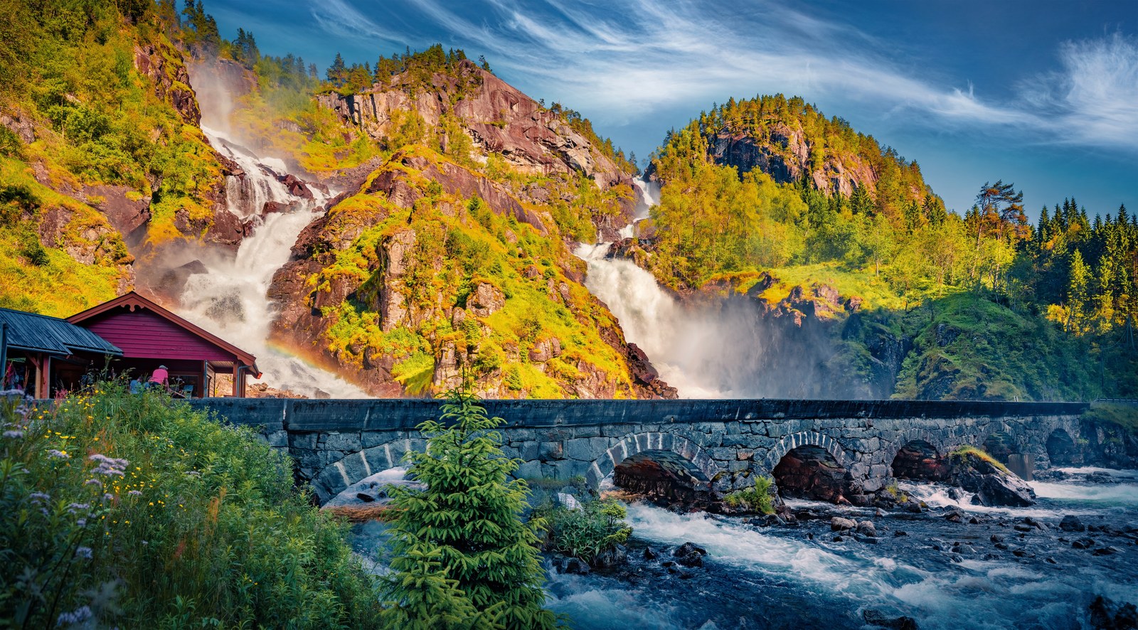
Låtefoss is the twin waterfall that most people heading for Trolltunga see without having to walk anywhere. It stands right beside National Road 13 in the Odda valley, about 16 km south of Odda by Store norske leksikon’s reckoning and around 15 minutes’ drive from the town according to Visit Hardangerfjord. Two white streams come down the same mountainside, fall a combined 165 metres and meet just above the road, where the water runs on under an old stone arch bridge. Visit Hardangerfjord calls it the main attraction of the Odda valley, which is often called the “Valley of Waterfalls”.
It is a roadside stop, not a hike, and that is both its charm and its problem. The parking area is small, the bridge is narrow and the spray reaches the tarmac. Below: where the falls are, why there are two of them, where the water comes from, the real age of the bridge in the photographs, when the falls run fullest, how to stop without causing a jam, and the other waterfalls of the valley.
The short answer
- What it is: two waterfalls side by side, Låtefoss to the north and Skarsfoss to the south, which together are usually called Låtefoss or Låtefossen.
- Where: beside National Road 13 between Odda and Røldal, about 16 km south of Odda; around 15 minutes by car from Odda and about 30 minutes from Røldal.
- How high: 165 metres in total, 51 of them in free fall, according to Kringom, the local-history encyclopedia run by Vestland County Council and the University Museum of Bergen.
- Where the water comes from: the lake Lotevatnet, 340 metres above sea level, on the river Austdølo.
- The bridge: a six-span stone arch bridge completed in 1859, widened in the mid-1940s.
- Cost and access: free and open year-round; the stop is listed as wheelchair accessible.
- Best time: late April to early July, when snowmelt drives the waterfalls of Hardanger hardest.
Where Låtefoss is
The Odda valley, Oddadalen, runs south from the town of Odda, at the head of the Sørfjorden. Above Odda lies the lake Sandvinvatnet (also spelt Sandvinsvatnet), and above that the valley narrows and climbs towards Røldal. National Road 13 follows the river through it. It is the same road 13 that runs along the Sørfjorden to Odda from the north, and our guide to getting to Trolltunga covers that part of the journey.
Låtefoss is on the east side of the valley, where the side river Austdølo (Austdøla in Kringom) comes down from the mountains. Store norske leksikon notes that the road crosses Austdølo roughly where the two falls meet, which is why the view from the car is so immediate: the waterfall is not in the distance but right above you. It is also the southern end of the Norwegian Scenic Route Hardanger, whose four sections include one from Kinsarvik to Låtefoss.
If you are staying near Trolltunga, the geography is simple. Tyssedal, where the road to the trailhead begins, lies 6 km north of Odda; Låtefoss lies south of it. So the falls are not on the way to the hike itself, but they are a short drive from any of the usual bases. Our guide to Odda covers the town and its other short trips.
Two waterfalls, one name
What everyone calls Låtefoss is, strictly, two waterfalls. Store norske leksikon explains that only the northern one is called Låtefoss; the southern one is Skarsfoss. Both run out of the same lake, Lotevatnet, and together they fall 165 metres. They run together just before they reach the main river of the valley, Storelvi, and from the road it looks like a single performance in two parts.
Kringom gives the shape of the drop: 165 metres down the mountain, 51 of them in free fall. The rest is a steep, broken run of white water, which is why the falls look so wide and lively rather than like a single ribbon dropping off a cliff.
The name has two possible origins. Store norske leksikon traces it to the lake Lotevatnet, which locals call Låtevatnet, and to the farm Låte north of the lake, from the Old Norse lòt, a vault or hollow, describing where the farm lies. The other reading is more fitting for a waterfall: låten, the sound of the falls, which can be heard a long way off.
Where the water comes from
Follow the water upstream and you climb in steps. Store norske leksikon gives Lotevatnet, the lake the two falls drain, at 340 metres above sea level, and the river Austdølo as flowing from Reinsnosvatnet higher up, at 594 metres. Kringom describes the same chain: Austdølo carries water from Reinsnosvatnet and, further down, from Låtevatnet.
Downstream, the falls feed Storelvi, which runs north through the Odda valley into Sandvinvatnet. That lake sits 87 metres above sea level and is dammed by a moraine at its northern end. From there the river Opo runs 2.5 km through the middle of Odda to the Sørfjorden. So the water you watch at Låtefoss reaches the fjord at Odda a few kilometres later.
The same lake also collects meltwater from the other side of the valley. Store norske leksikon notes that Sandvinvatnet and Storelvi get many tributaries from Folgefonna in the west, the most important being Jordalselvi from the glacier arm Buarbreen. Our article on Folgefonna and Buarbreen follows that water up to the ice.
One detail matters for the future of the falls: the Opo together with Austdølo is permanently protected against hydropower development. In a district where so much water has been put to work, as our article on the Troll Tongue and the hydropower story explains, Låtefoss is one of the rivers that was left alone.
Why the falls are there: a river that could not keep up
Most waterfalls in western Norway are explained by ice. A big glacier deepened the main valley more than the small glaciers in the side valleys, leaving the side valleys hanging, and their rivers now fall into the main valley. Kringom points out that Låtefoss is different.
The valley of Storelvi follows a fault zone with many cracks and loose rock. During the ice ages, glaciers dug out the fjords and gave Storelvi a much shorter and steeper route to the sea. Working in broken rock, the main river was able to cut down quickly. Austdølo, the side river, had firmer bedrock and less water, so it could not keep pace. The difference in height between the two is the waterfall.
That also explains the twin form. Kringom notes that the two almost equal falls come from the same lake because it has two outlet sills at about the same height. Water spills over both, and each spill becomes a waterfall. It will not last forever: in the distant geological future, Kringom says, the falls will be gone, once Austdølo has adjusted to the valley floor that Storelvi has carved out. For now, in Kringom’s phrase, Austdølo is an unadapted river.
The same broken rock that made the falls also makes the valley unsettled. Kringom notes that stones often fall onto the road here and that there have been plans to put this stretch of the road into a tunnel. Check the road status before you travel, especially after heavy rain.
The stone bridge of 1859, and the part that is newer
The bridge is half the picture. Visit Hardangerfjord describes the water from the falls gathering and flowing beneath the characteristic stone arch bridge, one of the most photographed scenes in Hardanger, and says the old bridge was completed in 1859.
Kraftmuseet, the hydropower and industry museum in Tyssedal, adds the detail in its photo archive. Låtefoss bru is a stone arch bridge of six spans, begun in 1857 and completed in 1859, the first major single project along the road. It was 60 metres long, about 4.5 metres high and only 3.6 metres wide for traffic. Like many stone arch bridges it is not solid stone: the dressed blocks form a shell, filled inside with sand, gravel and smaller stones.
Then the road grew. In the mid-1940s the bridge was widened by about 2 metres towards the river, bringing the total width to over 6 metres with a 5.5-metre asphalt carriageway. Kraftmuseet makes a point that most descriptions miss: the face of the bridge that tourists see and photograph today was built as a road widening, not in 1859 or 1860 as many believe. The 1859 bridge was widened rather than replaced, so the side in most photographs is the later addition.
Horse, carriage and the first tourists
Låtefoss was famous long before cars. The Norwegian Scenic Routes describe frequent visitors from Britain and Germany in the 19th and early 20th centuries, brought by horse and cart from the fjord, along Sandvinvatnet and up the Odda valley. Visit Hardangerfjord says tourists came out from Odda by horse and carriage to see the waterfall and the views of the valley.
Kringom’s history of Odda as a tourist town explains the scale. Tourism really took off when the sea route between Newcastle and Bergen opened in 1890. In 1904 Odda had 83 calls by foreign tourist ships, and in all 12,000 tourists arrived by sea. Kaiser Wilhelm II was a guest in Hardanger every year from 1889 to 1914, and Odda filled with hotels, among them one called Hotel Låtefoss. The boom ended with the outbreak of the war in 1914, and the hydropower industry that followed changed the town’s character, as our article on the Troll Tongue describes.
Låtefoss, in other words, has been a fixed stop for well over a century, and the old road above it was built for those visitors.
The old road to the viewing café
Most people photograph the falls from the bridge and drive on. A few walk up. Visit Hardangerfjord and Kraftmuseet both describe a historic chaussée road, an old built road that the waterfall guide calls a cobblestone path, which begins about 50–60 metres south of the bridge and climbs the mountainside on the eastern side of the valley.
It leads to a viewpoint above the waterfall and to the ruins of the old viewing café, where tourists once stopped for refreshments while admiring the falls. Kraftmuseet notes that the road was built for that café. Visit Hardangerfjord asks walkers to take care on the short stretch along Rv13 between the parking area and the start of the old road.
It is the best way to see the falls without traffic around you, and it gives a sense of how the place worked for those early carriage tourists. Wear shoes with grip: everything near a waterfall is wet.
When Låtefoss runs fullest
Waterfalls in Hardanger follow the snow. Visit Hardangerfjord says late April through early July is when the waterfalls are at their most powerful, fed by snowmelt from the Hardangervidda plateau and the surrounding mountains, and that May is particularly impressive, with roaring sound and mist. Water levels drop somewhat in August, and autumn brings fresh surges after rainfall.
Rain helps too. At the Odda – Jordal weather station, the normal precipitation is 177.0 mm in September and 200.0 mm in October, against 73.0 mm in July, so an autumn visit after a wet few days can be as dramatic as early summer. Our article on Trolltunga weather and the best time to go has the full monthly table.
Unlike the hike, Låtefoss is open year-round and free. In winter, ice and snow can make the parking area and the roadside slippery, so check the road conditions before you set out.
Stopping safely
The single most important thing at Låtefoss is the traffic. Visit Hardangerfjord is frank about it: the parking area near the waterfall is small; on the most popular days there can be queues and limited parking, and cars sometimes have to wait for a space. Traffic across the narrow bridge may move slowly when many visitors stop to take photos.
A few rules of thumb follow from that:
- Park only in the parking area. Do not stop on the bridge or on the carriageway for a photo, however tempting. Visit Hardangerfjord asks drivers to be considerate of traffic and to follow the signs in the area.
- Expect a wait in summer. Visit Hardangerfjord warns that the area can become very busy during the summer season, because the falls sit on the main road through the valley. Arriving early or late in the day gives you a better chance of a space.
- Walk on the safe side. The bridge is narrow. Watch for traffic, keep children close and do not stand in the road to frame a picture.
- Watch the surface. The Norwegian Scenic Routes note that the spray showers the road. Wet tarmac and wet stone are slippery.
- Accessibility. The Låtefossen stop is listed by the Norwegian Scenic Routes as wheelchair accessible, which makes it one of the easiest big waterfalls in the region to see.
Cyclists face their own issue: the Norwegian Scenic Routes advise riders to avoid the tunnels on the road from Kinsarvik to Odda and onwards to Låtefossen, riding instead on the old roads outside them.
Photographs and spray
Låtefoss is generous to photographers because it is close. The flip side is spray.
- Protect your gear. When the falls are high, mist drifts across the road and the bridge. A rain cover or even a plastic bag for the camera, and a cloth to wipe the lens between shots, will save frustration.
- Step back for the twin form. From the bridge you are almost underneath the falls. The two streams read better from the parking area or from the old chaussée road above, away from the traffic.
- Include the bridge, but know what it is. According to Kraftmuseet, the face you see from the parking area is a later road widening, not the 1859 original.
- Use the flow. In late spring the falls are at their whitest and loudest, which is when the spray is heaviest too; plan a dry spot to change lenses or wipe the camera.
The other waterfalls of the Odda valley
Låtefoss is the best-known waterfall of the valley, not the only one. Fjord Norway, quoting Visit Hardangerfjord, lists Tjørnadalsfoss, Strandfoss, Vidfoss, Espelandsfoss and Låtefoss along Route 13, lined up like pearls on a string within a radius of only a few kilometres. Drive slowly and you will see several more streams on both sides of the road in May and June.
Further afield, Visit Hardangerfjord calls the whole region “the kingdom of waterfalls”, and a few are worth knowing about if you have a spare day:
- Steinsdalsfossen, near Norheimsund, about 1 hour from Bergen: a paved path takes you behind the 50-metre waterfall without getting wet.
- Vøringsfossen, near Eidfjord, roughly 2 hours from Bergen: the big one, falling 182 metres into the Måbødalen valley. Our article on the Hardangerfjord covers it.
- Husedalen, above Kinsarvik: a hike past four waterfalls, 5 km one way with 700 metres of climbing.
- Furebergsfossen, beside route 551 between Årsnes and Sunndal, flows under the road straight into the Maurangerfjorden.
Fitting Låtefoss into a Trolltunga trip
If you are here for the Trolltunga hike, that is a long day: 27 km return from P2 Skjeggedal or 20 km from P3 Mågelitopp. Låtefoss fits around it rather than competing with it.
- On a rest day. After the hike, legs are tired and a roadside waterfall is about the right level of effort. Combine it with a slow drive through the Odda valley and a stop at the lake Sandvinvatnet.
- On a weather day. Trolltunga AS says never to hike to Trolltunga in strong wind, heavy rain or fog. Låtefoss is at its best after rain, needs no view of the plateau and takes an hour or less. It is a good use of a day when the hike is off.
- On arrival or departure. If you come via Røldal from the south, the falls are on your route into Odda.
Our Trolltunga hike guide covers the hike itself, and our article on where to stay near Trolltunga compares Odda, Tyssedal and Lofthus as bases. The guided Trolltunga trips on our tours page take care of the logistics for the main event, which leaves the waterfalls for your free time.
Frequently asked questions
How high is Låtefoss?
The twin falls have a combined drop of about 165 metres, a figure given by Store norske leksikon, Visit Hardangerfjord and Kringom. Kringom adds that 51 metres of that is free fall; the rest is a steep cascade.
Where is Låtefoss?
In the Odda valley in Ullensvang, Vestland, right beside National Road 13 between Odda and Røldal. Store norske leksikon puts it about 16 km south of Odda, and Visit Hardangerfjord says it takes around 15 minutes to drive from Odda.
Why are there two waterfalls at Låtefoss?
Both streams drain the same lake, Lotevatnet, which has two outlet sills at about the same height. Water spills over both, so you see two falls, Låtefoss in the north and Skarsfoss in the south, which meet just above the road.
Is Låtefoss free to visit?
Yes. Visit Hardangerfjord lists it as free to visit and open year-round. The parking area is small and fills up on busy summer days, so be prepared to wait or come early.
When is the best time to see Låtefoss?
Late April to early July, when snowmelt makes the waterfalls of Hardanger most powerful, with May often the most dramatic. Water levels drop somewhat in August, and autumn rain can bring the falls back up.