Geology
Troll Tongue, Norway: How Trolltunga Formed and the Story Behind It
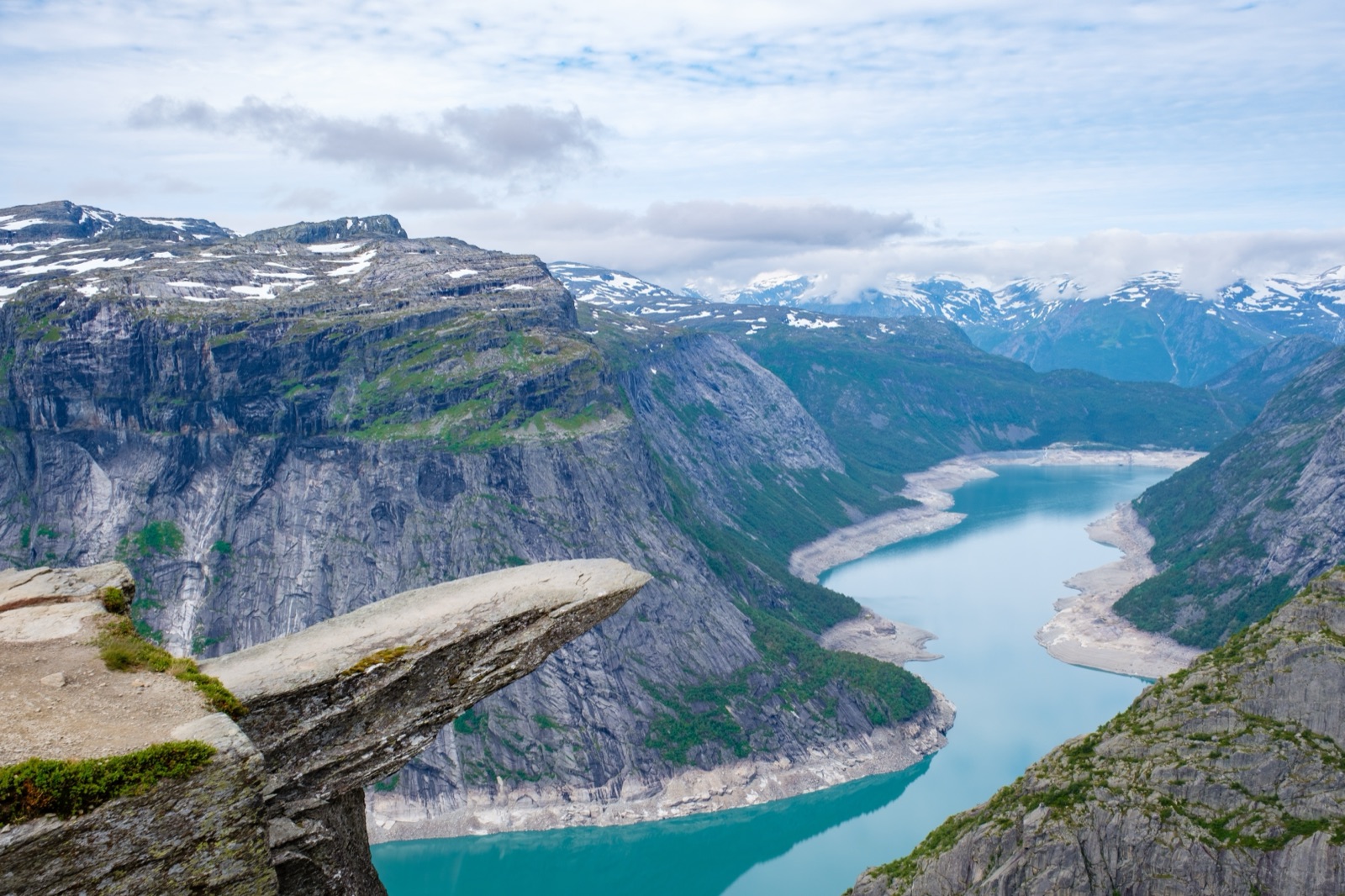
Trolltunga, the “troll tongue”, is a flat ledge of ancient bedrock that juts horizontally out of a cliff above the lake Ringedalsvatnet, east of the village of Tyssedal in Ullensvang municipality, in Vestland county in western Norway. Trolltunga AS, the company owned by Ullensvang Municipality that maintains the trail, gives its height as 1,180 metres above sea level and describes it as perched 700 metres above the lake. There is no road to it: you reach it on foot, on a long day hike over the western edge of the Hardangervidda plateau.
The tongue is a leftover of the last Ice Age. The usual account of its geology is that water from a glacier froze in the cracks of the cliff and prised off large, angular blocks, which the ice then carried away, leaving the overhang behind. The lake below is no longer quite natural either: since 1918 it has been held back by Ringedalsdammen, a granite-clad dam built for one of the pioneering hydropower schemes of Northern Europe. Below: the name, the conflicting height figures, the geology, the industrial story of the valley, and how Trolltunga compares with Norway’s other famous cliffs.
The short answer
- What it is: a horizontal tongue of rock projecting from a vertical cliff on the north side of Ringedalsvatnet.
- Where: east of Tyssedal, a village six km north of Odda on the Sørfjorden in Hardanger.
- How high: about 1,180 metres above sea level, according to Trolltunga AS and Store norske leksikon. Other references give 1,126 or 1,100 metres.
- How far above the lake: 700 metres in Trolltunga AS’s description; Store norske leksikon puts it at around 800 vertical metres above the lake’s lowest water level.
- How it formed: glacial ice and frost broke blocks away from the cliff during the last Ice Age.
- How many people go: around 80,000 hikers a year, up from 800 in 2010.
What the name means
Wikipedia glosses Trolltunga as “the troll tongue”, and the name describes exactly what you see in the photographs: a thin slab poking out over empty air, as if the mountain were sticking its tongue out at the valley. English speakers often say “Troll’s Tongue” or “Troll Tongue”; in Norway it is simply Trolltunga.
The names around it are older and more down to earth. Ringedalsvatnet, the lake below, probably takes the first part of its name from the river name Ringa, which Store norske leksikon links to the word ring and to a rounded bend in the river. Along the trail, the name Store Floren shows that farmers once used the area as summer pasture, and Hestaflåene is described by Trolltunga AS simply as a place where horses grazed. The everyday names show that this high ground was worked long before anyone came to photograph it.
Where Trolltunga is
Trolltunga lies in Ullensvang municipality, in Vestland county. The nearest town is Odda, at the head of the Sørfjorden, a long southern arm of the Hardangerfjord. The closest village is Tyssedal, which Store norske leksikon describes as lying at the mouth of the river Tysso on the east side of the Sørfjorden, six km north of Odda. It is small: 596 inhabitants in 2025.
From Tyssedal a road climbs up the Tyssedalen valley to Skjeggedal, where the main trailhead sits near the dam at the end of Ringedalsvatnet. The rock itself is on the north side of the lake, high on the cliffs, and the walk to it runs across the plateau rather than along the shore. From the tongue, Store norske leksikon notes, the view takes in the mountains around Ringedalsvatnet, the Hardangervidda plateau and, to the west across the Sørfjorden, the Folgefonna glacier.
Getting to the area takes planning. Trolltunga AS lists the journey to Odda as about 2.5 hours from Haugesund, 3 hours from Bergen, 4 hours from Stavanger and 6 hours from Oslo. Our guide to getting to Trolltunga covers the roads, buses and car parks in detail.
How high is Trolltunga?
Ask four sources and you get three heights. None of them is wrong; they measure from different places and round differently.
| Source | Height above sea level | Height above the lake |
|---|---|---|
| Trolltunga AS | 1,180 m | 700 m |
| Store norske leksikon | around 1,180 m | around 800 m above the lowest water level |
| Wikipedia | 1,126 m | about 700 m |
| De Historiske (hotel listing) | 1,100 m | not given |
The difference in the drop to the lake is easy to explain. Ringedalsvatnet is a regulated reservoir, and Store norske leksikon gives its surface as lying anywhere between 464 and 373 metres above sea level, depending on how full it is. Subtract the higher level from 1,180 metres and you get roughly the 700 metres that Trolltunga AS quotes; subtract the lower level and you arrive at the encyclopedia’s figure of around 800. The tongue stays put, the water moves.
The hike climbs most of that height. Trolltunga AS lists P1 Tyssedal at 144 metres above sea level, the main trailhead at P2 Skjeggedal at 415 metres, and the upper car park at P3 Mågelitopp at 860 metres. Once you reach the plateau, at an altitude of 900 metres or so, the terrain is relatively flat but full of ups and downs. From P2 the round trip is 27 km and takes 8–12 hours; from P3 it is 20 km and 7–10 hours. Store norske leksikon gives 28 kilometres and about 10–11 hours from the end of the road. Our Trolltunga hike guide goes through the route stage by stage.
How the ice made the tongue
The rock of Trolltunga is very old. Wikipedia’s outline of its geology describes the cliff as part of the Precambrian bedrock, and places its shaping in the last Ice Age, when the edge of the glacier reached the cliff. Water from the glacier froze in the crevices of the mountain and broke off large, angular blocks, which the glacier then carried away. Atlas Obscura sums up the same process in a sentence: the ledge was made thousands of years ago by water from a glacier freezing off part of the rock.
The mechanism is simple physics. Water expands as it freezes, so ice forming in a crack acts as a wedge. Repeat the freeze and thaw often enough and a crack widens until a block comes loose. Beside a glacier, with meltwater on hand and temperatures hovering around freezing, that process runs again and again, and the moving ice clears away the debris. What remained at Trolltunga was the part of the cliff that held together: a flat slab with nothing underneath it.
Sources differ on what to call the rock. Wikipedia describes the cliff as gneiss; Trolltunga AS, in its note on the Norwegian Scenic Hike label, calls the tongue a large granite slab. Gneiss is a metamorphic rock and granite an igneous one, but both are hard, crystalline rocks, and the distinction matters more to geologists than to the hiker standing on it.
The cracks, and why nobody needs to stand at the very edge
Wikipedia notes that deep cracks remain along the cliff, one more reason to respect the drop. There is no safety rail at the ledge, as Atlas Obscura points out. Four iron rebar steps lead down onto the tongue, and Trolltunga AS asks hikers to stay at least a couple of feet back from the edge, noting bluntly that a fall would be fatal.
At Preikestolen, the best-known cliff in the Lysefjord, Store norske leksikon explains the crack pattern as pressure-release cracks, formed when the glacier in the fjord basin melted away just over 10,000 years ago and the weight of the ice disappeared. The sources used here do not describe Trolltunga’s cracks in that detail, so we do not claim the same cause; what the two cliffs share is a recent past under ice.
Ringedalsvatnet: the lake that became a reservoir
Ringedalsvatnet is the long lake that fills the valley below the tongue. Store norske leksikon describes it as a lake in the Tysso watercourse, east of Tyssedal, measuring 4.6 square kilometres. From it the river Tysso runs down to the Sørfjorden at Tyssedal.
It is also a battery: the main reservoir, holding 426 million cubic metres, for the Oksla power station on the Sørfjorden at the northern end of Tyssedal. That is why its level moves so much. In photographs the lake looks like wilderness; it is a working reservoir all the same.
Ringedalsdammen, Norway’s largest dam of 1918
At the western end of the lake, near the trailhead at Skjeggedal, stands Ringedalsdammen. According to Store norske leksikon, it was the largest dam in Norway when it was completed in 1918. It is a concrete gravity dam faced with granite, 520 metres long and up to 33 metres high. Lokalhistoriewiki adds that its crest was designed after the model of a medieval castle, and that the dam was faced on both sides with hand-dressed granite.
For hikers the dam is the first sign that the landscape around Trolltunga is as much industrial as natural.
Tyssedal and the hydropower pioneers
The dam existed to feed a power station. Lokalhistoriewiki records that construction of the Tyssedal power plant began in September 1906, and that in May 1908 it began supplying electricity to the smelting works in Odda. Store norske leksikon calls it the first high-pressure plant in Northern Europe, with a head of 400 metres between its intake and the turbines by the fjord.
The old station, Tysso I, ran from 1908 to 1989. It was protected as a technical and industrial heritage site in 2000 and is now part of Kraftmuseet, the Norwegian Museum of Hydro Power and Industry, which presents the industrial development and hydropower construction of the area in a historical perspective. The museum is also home to Elektra, the national hydropower monument, unveiled in 2000. On 19 June 2009 the Tyssedal plant, together with the Odda smelting works and the Rjukan–Notodden industrial heritage, was placed on Norway’s tentative list for UNESCO World Heritage.
The hydropower company also left its mark on where visitors sleep. Tyssedal Hotel, now a common base for the hike, was built in 1912 by the company as an administrative hub for its projects. Our guide to where to stay near Trolltunga covers it and the alternatives.
Tyssestrengene: the waterfall the power stations took
Long before Trolltunga became famous, the big sight in these mountains was a waterfall. Trolltunga AS describes Tyssestrengene as a twin waterfall that was Norway’s highest and one of the most magnificent in Europe, with a total height of 646 metres and a 312-metre free fall. In the nineteenth century it was one of the country’s premier tourist attractions.
Then the water was put to work. In 1967 the flow was diverted to Tysso II, a hydropower plant built deep inside the mountain in Skjeggedal. Hikers still cross the place where it used to run: at Tyssehøl the trail crosses a dry riverbed that once carried water to Tyssestrengene, and passes a dam. The view people now walk all day to see was once a sideshow to a far louder one.
An old road, summer pastures and working horses
The trail to Trolltunga was not cut for tourists. Trolltunga AS describes it as part of an ancient thoroughfare between western and eastern Norway, across the Hardangervidda plateau. Farmers drove livestock up here for the summer grazing, and along the way you may see remnants of old stables.
The hydropower years added a second layer. When the facilities were built in Tyssedal and in the mountains above in the early 1900s, horses carried materials and helped with the heavy construction work. Upland that once served cattle and travellers became a building site, and only much later a destination.
The Mågeli funicular
One relic of that building site shaped the Trolltunga hike for years. Mågelibanen was a two-track funicular in Skjeggedal. Lokalhistoriewiki records that it was built in 1911–1912 by the Tyssefaldene company to carry construction workers and equipment into the mountains. It was 960 metres long, with a height difference of 430 metres, and in places climbed at up to 42°. Its top station, Mågelitopp, at 860 metres above sea level, is the place that now gives its name to the P3 car park.
The line had a dark day. On 3 April 1955, with passengers aboard under a special Easter permission, the cable snapped on the steepest section; with no safety system to stop the car, two people were killed and several were badly injured. Later the funicular carried tourists for a period in the late 1990s and early 2000s, becoming part of the Trolltunga experience, until it was closed to commercial use for safety reasons in 2012. Today hikers reach Mågelitopp by the road or the shuttle bus instead.
From under a thousand visitors to around 80,000
Trolltunga’s fame is recent. Store norske leksikon notes that fewer than 1,000 people a year walked to it before 2010, and that 81,000 did so in 2019. Trolltunga AS gives a similar curve: from just 800 visitors in 2010 to around 80,000 hikers a year now.
That growth changed how the place is managed. Trolltunga AS, owned by Ullensvang Municipality, builds and maintains the trail, information boards, toilets and emergency shelters, runs mountain wardens and maintains the 5.4 km road, Skjeggedalsvegen. At the end of July 2021 the route was certified as a Norwegian Scenic Hike, the fourth trail to receive the label after Fosseråsa in Geiranger and Kjerag and Preikestolen in the Lysefjord. Up to 15 trails can be certified.
Popularity also means a queue for the famous photo. Trolltunga AS says the rock is busiest between 12:00 and 15:00 from about 20 June to 20 August, with waits of 30–45 minutes on weekdays and often around 60 minutes on Saturdays. It is usually most crowded on the first sunny day after several days of rain. Our article on Trolltunga weather and the best time to go looks at how the seasons change the picture.
Trolltunga, Preikestolen or Kjeragbolten?
Trolltunga is often mentioned in the same breath as two famous sights of the Lysefjord, Preikestolen and the Kjerag boulder. They are very different outings.
| Trolltunga | Preikestolen | Kjeragbolten | |
|---|---|---|---|
| What it is | a rock tongue over a lake | a flat-topped cliff over the Lysefjord | a boulder wedged in a crevasse |
| Height | about 1,180 m above sea level; 700 m above Ringedalsvatnet | 604 m above the fjord | 1032 m above sea level |
| Hike | 27 km return from P2 (8–12 hours) or 20 km from P3 (7–10 hours) | almost 8 km return, roughly 4 hours | 5 km each way, about 3 hours each way |
| Visitors | around 80,000 a year | around 350,000 in 2022 | roughly 50,000 a year |
| Usual base | Odda or Tyssedal | Stavanger | Stavanger |
Preikestolen, on the north side of the Lysefjord, has an almost flat top that Store norske leksikon measures at roughly 25 by 25 metres, and the Preikestolen Express bus takes about an hour from Stavanger city centre to the trailhead. Kjerag is harder: a 600 metre elevation gain, with chains on some of the most challenging sections.
The practical point is distance. Stavanger, the usual base for both Lysefjord hikes, is about 4 hours by car from Odda in Trolltunga AS’s journey times. Combining them means separate days and at least one long transfer. If you have time for only one, choose by stamina: Preikestolen is the shortest, Kjeragbolten has the chained scrambles, and Trolltunga is by far the longest day.
Seeing it for yourself
Trolltunga is a serious hike, and the rock at the end is the reward for a long day rather than a viewpoint you can drop in on. Our Trolltunga hike guide covers the route, timings and safety, and our guide to the via ferrata and guided tours explains the options with a guide, including overnight trips. You can compare current trips on our tours page.
Frequently asked questions
How high is Trolltunga above sea level?
Trolltunga AS and Store norske leksikon give about 1,180 metres above sea level; Wikipedia gives 1,126 metres and some listings round it to 1,100. Above the lake, Trolltunga AS says 700 metres, while Store norske leksikon gives around 800 metres above the lowest water level, because the reservoir’s level changes.
What does Trolltunga mean?
Wikipedia glosses Trolltunga as “the troll tongue”. The name describes the shape: a thin slab of rock sticking out horizontally from the cliff, like a tongue stuck out over the valley.
How was Trolltunga formed?
The cliff is part of very old Precambrian bedrock. During the last Ice Age, water from the glacier froze in cracks in the mountain and broke off large, angular blocks, which the ice carried away; the slab that held together was left as the overhang you see today.
Is Trolltunga higher than Preikestolen?
Yes. Trolltunga sits about 1,180 metres above sea level and 700 metres above Ringedalsvatnet, while Preikestolen juts out 604 metres above the Lysefjord. The Trolltunga hike is also much longer: 27 km return from P2 against almost 8 km for Preikestolen.
Was there ever a funicular up to Trolltunga?
There was a funicular, Mågelibanen, but it only went part of the way. Built in 1911–1912 to carry hydropower workers, it climbed 430 metres to Mågelitopp at 860 metres, carried tourists for a period, and closed to commercial use in 2012. Today the P3 car park and the shuttle bus serve the same spot.