Nature
Folgefonna and Buarbreen: The Glacier Above Odda
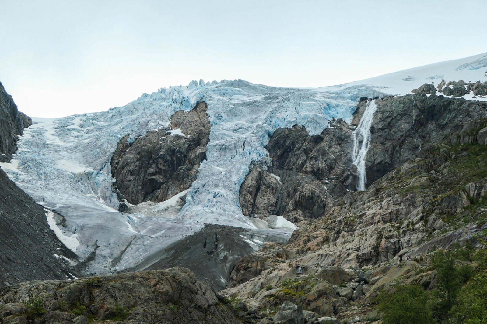
Folgefonna is the white line on the skyline across the Sørfjorden from Trolltunga. It is a plateau glacier on the peninsula between the Hardangerfjord to the west and, in Store norske leksikon’s description, two of its arms, the Sørfjorden to the east and the Åkrafjorden to the south, and the same encyclopedia ranks its southern part as Norway’s third-largest glacier. One of its arms, Buarbreen, reaches down towards the town of Odda, and a 3 km trail leads up the Buer valley towards it.
The glacier is shrinking fast. NVE, the Norwegian Water Resources and Energy Directorate, has measured the front of Buarbreen since 1900, and its record shows a retreat of 67 metres in 2026 alone. The summer ski centre on the glacier’s northern edge, which ran from 1989 to 2024, has closed because the ice surface had melted too far. Below: the ice cap in numbers, why it exists, how fast it is going, the walk to Buarbreen and the rules that keep you safe there, guided glacier walks, and how the meltwater ends up in the rivers and power stations of the fjord.
The short answer
- What it is: a plateau glacier in three parts, Søndre, Midtre and Nordre Folgefonna, covering about 187 km² in Store norske leksikon’s current figure.
- Where: on the Folgefonna peninsula, west of the Sørfjorden and Odda; you see it from Trolltunga across the fjord.
- Protection: Folgefonna National Park, created in 2005, covers 545 km² around the ice.
- Retreat: NVE’s record for Buarbreen (also spelt Buerbreen) shows a total front retreat of 1,301 metres since 1900.
- The walk: Buer to Buarbreen is 3 km one way, with 600 metres of ascent and about 4 hours of walking in total.
- The rule: do not go near the glacier front, and never walk on the ice without a guide.
- Summer skiing: over; the ski centre on Nordre Folgefonna ran from 1989 to 2024.
Folgefonna in numbers
Glacier figures change with every survey, so sources disagree, and the differences are part of the story.
| Measure | Figure | Source |
|---|---|---|
| Total area | about 187 km² | Store norske leksikon (glacier article) |
| Søndre / Midtre / Nordre Folgefonna | 154 / 9 / 24 km² | Store norske leksikon |
| Total area, 2006 aerial photos | 207 km² (including small glaciers) | Kringom |
| Total area, 1981 | 212 km² (including small glaciers) | Kringom |
| Length, south to north | 36 km | Store norske leksikon |
| Highest ice surface | 1,645 m | Store norske leksikon (glacier article) |
| Highest point, 2006 | 1,651 m (down from 1,662 m in 1981) | Kringom |
| Greatest ice thickness | about 500 m | Store norske leksikon (park article) |
| Ice volume | over 30 km³ | Kringom |
Store norske leksikon’s park article gives a larger glacier area of 203 km² and a highest point of 1,651 metres, while its glacier article gives 187 km² and 1,645 metres. Read together, they describe a glacier that is getting both smaller and lower. Visit Hardangerfjord calls Folgefonna the southernmost and third-largest glacier in Norway; Kringom puts Søndre Folgefonna third among mainland glaciers, after Jostedalsbreen and Vestre Svartisen.
Three ice caps, not one
The gorges Blådalen and Kvitnadalen divide Folgefonna into three: Søndre, Midtre and Nordre Folgefonna. Store norske leksikon gives them as 154, 9 and 24 km². The southern ice cap is by far the biggest and the one that matters near Trolltunga: its eastern arms come down above Odda.
It was not always three. Store norske leksikon’s park article notes that the glacier was continuous until the mid-1950s, and that steady melting has split it in three. At its widest, Søndre Folgefonna is 14 km across.
Like every plateau glacier, it collects snow on top and sends the surplus down in arms, or outlets. The best known are Øvre and Nedre Buarbreen on the east side, above Odda, and Bondhusbrea on the west side, which runs down towards the Maurangerfjorden. All three come off the southern ice cap.
Why there is a glacier here
Store norske leksikon credits two things for Folgefonna: its height above the sea and the great amounts of snow. Kringom explains that it sits on a high plateau close to the sea: moist winds from the south and west are forced up over it and drop extra precipitation as the air cools. Store norske leksikon gives 4,000–6,000 mm a year on top, about 70 per cent of it as snow, falling on 200 to 240 days. Kringom gives the dome about 5,500 mm a year, which makes it one of the wettest places in Norway.
The east side, the side facing Odda and Trolltunga, is much drier, because the air has already lost much of its moisture. Kringom compares two low-lying weather stations only 60 km apart: the normal is 3,070 mm a year at Indre Matre on the south-west side and 1,350 mm in Ullensvang on the north-east side.
It also has a literary history. Kringom traces the first description of the glacier to a book by Peder Claussøn Friis in 1613, more than two and a half centuries before Ibsen wrote Peer Gynt, whose line likens Folgefonna to a maiden lying in pure linen. In the east the glacier was once called Folgo, which Store norske leksikon connects to folge, a thin layer of snow.
Folgefonna National Park
Folgefonna National Park was created in 2005 as Norway’s 25th national park. Store norske leksikon gives it 545 km², mostly in Kvinnherad, with smaller parts in Etne and Ullensvang. Four landscape protection areas surround it, Ænesdalen, Bondhusdalen, Hattebergsdalen and Buer, bringing the protected area to about 600 km². Norway now has 48 national parks, according to Store norske leksikon and the national park website Norges nasjonalparker.
What makes it special, in Store norske leksikon’s description, is the relief: a thousand-metre fall almost straight down from the glacier edge to the fjord. The contrasts are sharpest in spring, from the snowfields down to the blue-green Sørfjorden with blossoming white apple orchards on the slopes. Our article on the Hardangerfjord covers that orchard country.
The park also has a place in science. At Bondhusbrea, the parish priest Nils Hertzberg of Ullensvang made the first glacier measurements in Norway. Several short marked paths lead to glacier fronts, including at Bondhusbrea, up the Keiserstien, up from Tokheim and at Buarbreen, and Folgefonna is a popular area for spring ski touring.
How fast the ice is going
The best measure of a glacier’s health is its front. NVE explains the method: the distance from a fixed point, such as a cairn or a bolt, to the glacier is measured in the same direction every year. The first systematic measurements in Norway began around 1900, on Jostedalsbreen, Folgefonna and others, and NVE has run the programme since 1994. Kringom notes that it was the geologist J. Rekstad who started annual measurements of Buerbreen and Bondhusbrea in 1900.
The results are stark:
- Buarbreen (Buerbreen): a cumulative change of minus 1,301 metres since 1900. The last three measurements show retreats of 33 metres in 2024, 40 metres in 2025 and 67 metres in 2026. In 2000 the cumulative figure stood at minus 721 metres, so the front has pulled back a further 580 metres since then.
- Bondhusbrea: a cumulative change of minus 1,051 metres, including 64 metres in 2026.
Not every year is a loss. Store norske leksikon notes that Folgefonna stayed roughly constant in size in the 1980s and grew a little in volume in the 1990s, like other Norwegian glaciers, because of snowy winters. NVE’s Buarbreen record shows an advance of 160 metres for the period 1988–95, measured from maps, and Kringom records Nedre Buarbreen advancing 42 metres in 1994–96. Since then, in Store norske leksikon’s words, the glacier has retreated strongly because of a warmer climate.
The area figures tell the same story: 212 km² in 1981 and 207 km² in 2006 by Kringom’s count, against Store norske leksikon’s current 187 km².
Buarbreen: the glacier arm above Odda
Buarbreen is the name of two glacier arms on the east side of Søndre Folgefonna, west of Odda. Store norske leksikon explains that it was once a single arm but, as the glacier retreated, it split into Øvre and Nedre Buarbreen. Below it, the valley Buardalen, with the river Jordalselvi, runs down to the farm Jordal by the lake Sandvinvatnet. NVE spells it Buerbreen; both names are used.
Kringom’s account of the valley reads like a short history of climate. The glacier reached its greatest extent during the Little Ice Age, a period of advances from about 1650 to 1930. Photographs by Knud Knudsen, the Odda-born pioneer of Norwegian photography, show Buarbreen reaching furthest down the valley around 1890, and it was probably furthest forward in 1893, a full two kilometres further down than today. A hotel in the valley, visible in a Knudsen photograph from before 1880, was destroyed when the ice advanced a few years later.
By 1917, a photograph by Johan Rekstad shows the front had already retreated about 600 metres from that maximum. A new large advance in the 1930s laid fresh moraines about 50 metres inside the 1893 moraine, then the glacier melted back again, and by the 1960s aerial photographs show it had split in two.
The tourists came early. Kringom describes Buarbreen as an early goal for the thousands of visitors, mostly English and German, who came to Odda in the 1800s; back at their hotels they could enjoy drinks with ice from the glacier. Where the ice covered the ground just over a hundred years ago, new forest of birch and grey alder has grown, and you walk through it on the way up.
Walking to Buarbreen from Buer
The walk starts at Buer, west of Odda. Visit Hardangerfjord’s directions are simple: turn off route 13 where it is signposted Buer and drive to the end of the road, where there is parking by the National Park Farm at Buer. Campervans are welcome, and the listed parking price is NOK 185; check before you go. Visit Hardangerfjord’s listings do not quite agree on the distance: the glacier-hike listing puts Buer 9 km from Odda town centre, while the Trolltunga Camping listing places the campsite 2 km from the centre and 5 km from Buer.
The figures for the walk:
- Length: 3 km one way.
- Total ascent: 600 metres.
- Total walking time: 4 hours.
- Season: end of May to October in an average year.
The trail follows the river most of the way, crossing it on bridges, including a suspension bridge. In places there are ropes to help you climb rocky sections, and the last part is in steep terrain, so sturdy hiking boots are necessary. The glacier is in front of you the whole way.
Sources differ a little on time. Kringom gives a two-hour walk from the car park to the glacier tongue, while the guided-hike listing allows 1.5 hours each way. Visit Hardangerfjord’s total of 4 hours for the return is a fair planning figure, without counting time at the top. It is a much shorter day than Trolltunga, but it is not a stroll: wet rock, ropes and a steep finish make it a proper mountain walk. Our guide to Odda puts it alongside the town’s other walks.
Safety at the glacier front
Visit Hardangerfjord puts the rule in capitals: do not go near the glacier. It is in constant movement, and going near it can be very dangerous. For guided tours on the glacier itself, it points you to the tourist information in Odda.
NVE’s safety page explains why:
- Falling ice. The glacier front and sides can be unstable, and large ice blocks can fall at any time. Keep a safe distance from the edge and stay behind any barriers.
- Sudden water. Large volumes of water can suddenly be released at the glacier front.
- Crevasses. Anyone who hikes or skis on glaciers should have sufficient knowledge of glacier travel; NVE recommends a harness, rescue equipment and ropes.
So the practical line is clear. Walk up the valley, look at the ice from a distance, take your photographs and turn round. Never walk onto the ice or up to the front without a qualified guide and the right equipment. The Norwegian Mountain Code’s advice to turn back in time applies here as much as on the Trolltunga plateau.
Guided glacier walks
If you want to stand on the ice, go with a guide. Visit Hardangerfjord’s listing for Hardanger Breføring describes a short guided glacier hike on Buarbreen every day in summer, with no prior experience needed and the equipment provided. You walk up from Buer on your own, meet the guide at the blue hut by the glacier and are fitted with gear there.
As listed, departures are at 10:00 and 14:00, the age requirement is 13+, and the total duration is 6 hours, including the 1.5-hour walk on your own each way between the car park and the glacier; about 3 hours are spent with the guide. Bring a jacket, trousers, gloves, sturdy boots, food and drink. Prices and times change, so check before you book.
Elsewhere on Folgefonna, Folgefonni Breførarlag runs snowshoe trips, glacier walks, ice climbing and a ski traverse of Folgefonna from May, according to Visit Hardangerfjord. The trips on this site’s tours page are Trolltunga hikes rather than glacier walks, so book glacier trips directly with the local operators.
The end of summer skiing on Folgefonna
For decades Folgefonna was known for summer skiing. That has ended. Store norske leksikon notes that at the north-western edge of Nordre Folgefonna lie the ruins of the Folgefonna summer ski centre, which operated from 1989 to 2024, and that continued melting of the glacier surface made further operation impossible.
Fjord Norway’s listing for Fonna1199, the glacier centre at Jondal, says it is temporarily closed, but that the road to the Folgefonna glacier is open; for guided trips on the ice it points to Folgefonni Glacier Team. Plans can change, so check the current situation if a summer ski day was on your list. Spring ski touring is a different matter: Store norske leksikon still calls Folgefonna a popular area for it, for those with glacier skills or a guide.
From ice to fjord: the meltwater and the power stations
Folgefonna’s meltwater feeds the valleys below it, and much of it is put to work.
On the Odda side, Store norske leksikon notes that Sandvinvatnet, the lake above Odda, receives many tributaries from Folgefonna, the most important being Jordalselvi from Buarbreen. From the lake the river Opo runs 2.5 km through Odda to the Sørfjorden. The same lake also takes the water of Låtefoss, which our article on Låtefoss follows upstream.
On the west side, the water is harnessed on a large scale. Mauranger power station, with 250 MW installed and a mean annual output of 1,345 GWh, uses meltwater from Folgefonna brought through a tunnel under the 170-metre-thick Bondhusbrea. Kringom adds that by 1981 almost all the water under Bondhusbrea had been captured in the power-station tunnels. To the south-west, the river Blåelva is developed with six more power stations; together the seven have 380 MW installed and 2,016 GWh of mean annual output.
The roads go under the ice too. Folgefonntunnelen, on county road 551, runs partly under Folgefonna between Eitrem in Odda and Austrepollen. It is 11,130 metres long and opened in June 2001. The hydropower story on the Trolltunga side of the fjord, from Ringedalsvatnet to Tyssedal, is told in our article on the Troll Tongue.
Seeing Folgefonna from Trolltunga
You do not have to walk to Buarbreen to see Folgefonna. Store norske leksikon notes that the view from Trolltunga takes in the mountains around Ringedalsvatnet, the Hardangervidda plateau and, to the west across the Sørfjorden, the Folgefonna glacier. Trolltunga AS adds that in autumn the sun goes down towards Folgefonna, which is part of the appeal of a night on the mountain; our guide to camping at Trolltunga covers the rules.
The guided Trolltunga trips listed on our tours page make the same point: the summer hike with a guide includes views over Ringedalsvatnet and the Folgefonna glacier, and the winter snowshoe hike promises views over the lake and the glacier. Our Trolltunga hike guide covers the route, and our guide to the via ferrata and guided tours explains the overnight options. A good plan for a few days in Odda is the big hike on the best-weather day and the Buer valley on another.
Frequently asked questions
How big is Folgefonna?
Store norske leksikon gives the three parts together as about 187 km², with Søndre Folgefonna alone at 154 km², making it Norway’s third-largest glacier. Older surveys gave more: 212 km² in 1981 and 207 km² in 2006, including small glaciers nearby.
Can you walk to Buarbreen?
Yes, up the valley towards it. The trail from Buer, west of Odda, is 3 km one way with 600 metres of ascent and about 4 hours of walking in total, with ropes and bridges on the way. Do not go near the glacier front or onto the ice without a guide.
Is Folgefonna melting?
Yes. NVE’s record for Buarbreen shows the front 1,301 metres further back than in 1900, with retreats of 33, 40 and 67 metres in the last three measurements. The glacier split into three parts after the mid-1950s.
Can you still ski on Folgefonna in summer?
No. Store norske leksikon reports that the Folgefonna summer ski centre operated from 1989 to 2024 and that continued melting made further operation impossible. The glacier centre at Jondal is listed as temporarily closed, though the road to the glacier is open.
Do I need a guide for a glacier walk?
To go onto the ice, yes. NVE warns that ice blocks can fall from the front at any time and that glacier travel needs knowledge, ropes and rescue gear. Hardanger Breføring runs guided summer walks on Buarbreen, and the tourist information in Odda can advise.